

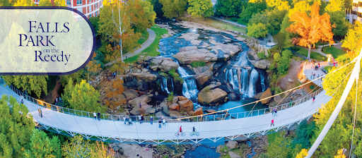
Leaders and residents in Greenville, South Carolina had been working for decades to transform their neglected, denuded downtown into a walkable, dynamic place. But the most significant catalyst was the removal of a highway bridge through downtown and the installation of a beautiful pedestrian bridge in 2004, creating a popular new attraction for people and restoring the city’s relationship to the river that birthed it.
History and context
Greenville, SC emerged from World War II as a thriving mill town. In the 1950s, this prosperity drove development into the suburbs, replacing the residential neighborhoods downtown with department stores and restaurants. While cars were becoming the primary mode of transportation, people continued to return to walkable Main Street, the hub of retail and social life. Many consider this decade to be the economic heyday of Greenville.
The 1960s brought changes to Greenville, similar to many cities across the United States. Increased sprawl, fueled by nearly free federal money for new highways, drove demand for highway access, and decision makers didn’t think twice about displacing residents and businesses to build infrastructure. Following the conventional wisdom of the day, and plenty of assistance from the South Carolina DOT, Greenville was transformed.
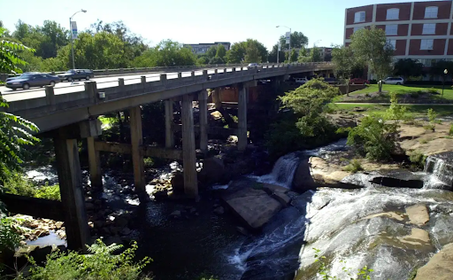
In 1960, the city built the Camperdown Way Bridge, a four-lane highway overpass, across the polluted Reedy River and Falls, the very spot where the earliest settlers gathered and eventually founded the city. Located in the West End section of the city (though technically positioned on the southern end of Main Street), the Camperdown Way Bridge turned this once-warehouse district into “a place you drove through…nothing but derelicts and dilapidated buildings.”1
Saving Main Street
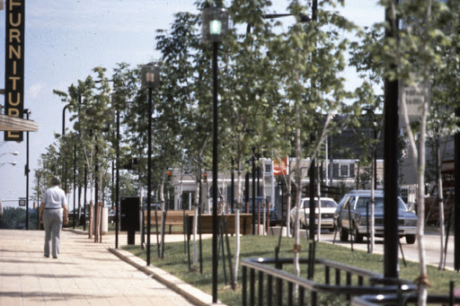
In 1968, the Greenville downtown development plan proposed a redesign of Main Street to create “a pedestrian friendly environment” in the name of economic revitalization. Max Heller, the Mayor of Greenville from 1971-79, was determined to bring this plan to fruition. Fighting upstream against the prevailing wisdom of the day when it came to accommodating vehicles at all costs, Heller’s vision of Main Street included a lane reduction (four-lanes to two-lanes), angled parking, street trees, lighting, and widened sidewalks suitable for outdoor dining. His government formed public-private partnerships to maximize success implementing the 1968 plan, and downtown began to flourish. While Keller’s continued influence fostered the extension of Main Street into the West End (1981), the neighborhood lagged behind, continuing to struggle for two more decades.

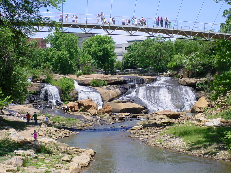
Restoring the city’s relationship to the river that birthed it
Throughout Greenville’s infrastructure transitions, the Carolina Foothills Garden Club was working on a transition of its own: giving pedestrians, not cars, priority access to the Reedy River and Falls Park and in doing so, restoring the history of the city. But realizing the full fruit of their effort would take decades.
The Club, with support from the City and Furman University, reclaimed the land in 1967. Although still hidden under the unsightly Camperdown Way Bridge, the park began to re-emerge in the 1970s. The shutdown of the mills together with the Clean Water Act (1972) resulted in a much cleaner Reedy River. The following year, 1973, the park was listed on the National Register of Historic Places. This was just the beginning.
In the 1980s, a group of performing artists set their sights on replacing Greenville’s last industrial complex with a center for the arts. The Peace Center, opened in 1990 on the south end of Main Street, is seen as the link between Greenville’s natural resources and Main Street. Its success inspired the Duke Power Company to fund infrastructure upgrades, carrying the feel of Main Street to the West End. Today, a footpath connects Falls Park, the Peace Center, and the West End.
Efforts to tear down the Camperdown Way Bridge began in earnest during the 1990s. The Greenville Central Area Partnership (GCAP) funded a study of the bridge in 1989, with a clear finding that the bridge “needed to come down. It blocked views of the majestic falls…. It divided the area. It made any potential growth moot.”2
This was quickly followed by a city-funded feasibility study in 1990 with outcomes focused on the chaos that would certainly ensue if the bridge was removed, the exorbitant cost to drivers for fuel (due to rerouting)—not to mention the embarrassment of removing perfectly good bridge paid for by the state. In spite of the latter findings, an independent task force recommended removing the bridge in 1991. But there was still a long road ahead.
Replacing a highway bridge with a people bridge
In 1995, Knox White was elected mayor of Greenville (1995-present). A former city council member, White was a longtime advocate for removing the Camperdown Way Bridge. He immediately began using his new position to lobby for removal. Together with his ally in the arts, Virginia Ulderick, White gained support from the governor by showing him the falls on a site visit to the future home of the South Carolina Governor’s School for the Arts and Humanities. The opening of the school (1999) clinched the turnaround for the West End, bringing foot traffic back to the area and strengthening the call to remove the unsightly obstacle standing in the way of resurgence. White next welcomed the head of the state Department of Transportation to visit the school and the park, in an effort to convince the state to give the bridge to the city. Then a state senator. Finally, he began to gain ground.
Even following another traffic study (1998) calling for removal of the bridge, there was still dissent. Naysayers were more interested in roads being fixed, traffic increasing, and any risk of stifling development in the West End just as it was getting going. White recognized the need for a “story,” something beyond tearing down a bridge, something that looked ahead, to the future of Greenville. He found exactly that in the decades-old vision of the Garden Club: a pedestrian bridge over the falls. In 2000, the Camperdown Way bridge became part of the Greenville road system. Greenville published the Reedy River Corridor Master Plan, funded through hospitality tax money, and set about the process of removing the Camperdown Bridge, restoring access to the river, and making the once-hidden falls a showpiece attraction once more.
Within five years, the Camperdown Bridge came down (2002) and the Liberty Bridge opened (2004), funded through the city council budget. Foot traffic replaced vehicle traffic. Liberty Bridge quickly became known as an architectural and engineering marvel, meant to emphasize the livable, walkable beauty of Greenville.
Today Greenville, South Carolina is alive with pedestrians. What began with Max Heller’s vision for a walkable Main Street grew to include the beauty of Falls Park. The West End of Greenville is now a thriving mixed-use residential neighborhood, known for its artistic community and proximity to nature. A network of paved trails extends through multiple parks, over Liberty Bridge, around the city, and beyond. While the city is still ringed by plenty of other highways, including another highway viaduct through the heart of the city, downtown Greenville is now a thriving, walkable urban center.
Lessons for Community Connectors
Greenville demonstrates a few impactful lessons for future reconnecting communities projects.
First, leadership and advocacy from the local government can be the driving force of change. Max Healer and Knox White recognized and fought for the potential they saw in Greenville. They used the power of their positions to change the direction of the community, resulting in economic and cultural success.
Second, partnerships go a long way in achieving a vision. The buy-in of public companies helped initiate the redevelopment of Main Street. Their combined vision and advocacy uncovered the natural beauty for which Greenville is now known. Artists also took part in the collaborative work of connecting nature, downtown, and history.
Third, attractions accessible to both visitors and residents foster success. Paved walking paths connect Falls Park and the Peace Center to each other, to the West End, and to Main Street. In a single walk or bike ride you can be in nature, experience art, dine in a local restaurant, and return to your home or a hotel.
Finally, in the words of Knox White, “Find your waterfall!!!” Find what is distinct, what makes your city unique, what features create this “place.” That is the first challenge. Only then can you draw in residents and tourists—who will not just live, work, shop, and dine, but will love this beautiful, walkable, historical (yet innovative), locale.
Urban areas, including but not limited to city centers, grow stronger through investments in walkability (and transit). Urban walkability creates a livable, connected community. Foot Traffic Ahead outlines this concept, using the top 35 largest metropolitan areas as examples. From Greenville, as well as Foot Traffic Ahead, cities can determine which aspects of their predecessors’ paths apply to their own future connected communities.
The post Greenville, SC: Out with the cars, in with the people appeared first on Transportation For America.